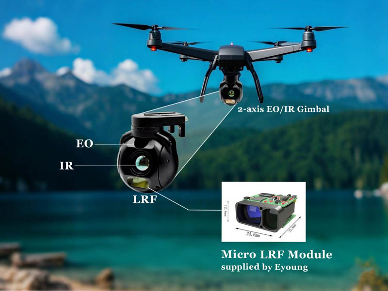
Accuracy is paramount in UAV operations, especially when navigating through complex environments or executing tasks such as terrain mapping or structural inspections. Laser rangefinders deliver real-time distance data with centimeter-level accuracy. This capability minimizes errors and allows operators to make informed decisions on the fly. Whether determining the altitude above a surface or calculating the distance to an object, the laser rangefinder enhances the UAV's capacity to operate with meticulous precision.
In dynamic operational theaters, such as surveillance or defense missions, acquiring and tracking targets swiftly can mean the difference between success and failure. The integration of laser rangefinders enhances a UAV's ability to pinpoint targets, measure exact distances, and maintain situational awareness. This capability supports rapid response and informed decision-making, critical in high-stakes environments.
The inclusion of a laser rangefinder module within the gimbal payload optimizes mission workflows. Tasks that previously required manual intervention or multiple data points are streamlined. With real-time feedback and accurate distance readings, UAVs can complete complex missions more efficiently, reducing both operational time and resource expenditure. This efficiency translates into greater mission success rates and increased ROI for UAV deployments.

In defense sectors, UAVs equipped with laser rangefinders support reconnaissance, surveillance, and target acquisition. They allow forces to assess threats, designate targets, and coordinate movements with unparalleled accuracy, all while maintaining a safe distance. Border patrol, crowd monitoring, and tactical support are just a few applications where this integration proves invaluable.
For civil engineering and infrastructure maintenance, UAVs with laser rangefinder capabilities can assess structures such as bridges, towers, and pipelines. The precise distance measurements facilitate detailed inspections, identify structural anomalies, and aid in creating accurate 3D models for further analysis, ensuring both safety and regulatory compliance.
In agriculture, laser rangefinders help determine canopy height, assess crop density, and measure terrain undulations. Environmental monitoring efforts benefit from this technology in applications like forest surveying, erosion mapping, and wildlife habitat assessment. The integration of laser rangefinders enables UAVs to deliver accurate, actionable insights in vast and often inaccessible terrains.
Every additional gram in a UAV's payload impacts flight time and maneuverability. Laser rangefinders must be compact and energy-efficient to fit within strict weight and power budgets. Engineers must balance performance with these constraints, ensuring that integration does not compromise the UAV's flight dynamics.
Seamless data transfer and synchronization between the laser rangefinder and the UAV's onboard systems are essential. High-speed processors and robust data links ensure that distance measurements are immediately available for decision-making or automated responses, maintaining the integrity of real-time operations.
Laser devices must adhere to strict safety standards, especially concerning eye safety and electromagnetic interference. Additionally, UAV operations must comply with airspace regulations, requiring careful planning and integration to meet both technological and legal benchmarks.
NEXT